Constructing Multi-Use Trails

Routes1,2

It is better to propose several different trail routes, of different lengths or levels of challenge. The best trail systems include a variety of routes that allow rides of 2 to 3 hours, a half-day, and a full day or more. Tracks with loops allow users to explore more paths covering a smaller area.

Horse trails should usually be designed to cover a least 5 miles. It takes 1 to 2 hours for most equestrians to ride an average 5-mile trail.

Trails should provide reasonable access to water. According to the Forest Service, water must be provided at intervals of no more than 10 miles. If water is not available within this distance, riders should plan to circle back to their trailers. In areas with very hot weather, consider including water sources at 5 to 6 intervals.

Bridge design1,3

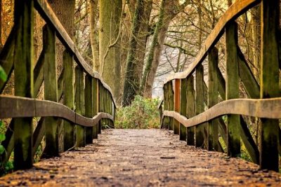
Bridges require a special designs fitted to each type of use. On national forests, all bridge designs must be approved by Engineering before being constructed. Some regions have standardized, approved designs for simple bridges.

For equestrian use, you need heavy-duty construction when it comes to bridges. Bridges must be designed to support every user, including service vehicles.

Bridges are expensive, so it makes sense to take good care of them. Check foot logs and bridges annually for problems. Loose decking, planking, curbs, or handrails should be repaired as soon as possible. Clean debris and organic material from all exposed wood surfaces on the bridge. The Forest Service requires all bridge structures to be inspected by a certified bridge inspector at least every 5 years.


Materials

Materials

Choosing the materials for a bridge is not a simple process.

Often, materials are imported to avoid the problem of “clearcuts” near the bridge. Pressure-treated wood, metal, concrete, wood laminates, and even fiber-reinforced polymers are being used in bridges.

Width

Width2,4

No national standards establish the width of shared-use trails. Determining the best trail width is site-specific and depends on many factors, including safety, types of trail users and their needs.

Usually, horses and mules require a tread that's at least 1.5 to 2 feet wide. The trail animal and rider require about 4 feet of unobstructed width, and pack stock with loads require a minimum unobstructed width of 5 feet. If stock frequently carry bulky items, the suggested minimum clearing width is 6 feet.

Surfaces

Surfaces3

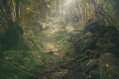
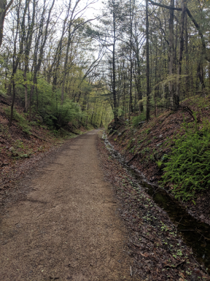
Trail surfaces could be hard (e.g. soil cement, granular stone, asphalt) or soft (e.g. natural earth, wood chips) according to the material’s ability to absorb or repel moisture.

Hard-surfaced materials are more practical for multi-use trails. It encourages more users to use it.

Softer surfaces are more comfortable if you are riding a horse but limits your speed. The softer the surface, the slower the speeds a horse can go.

Hard-packed soil

It will support most user groups; however, bicyclists and horseback riders will have the greatest impact on the surface.

It is inexpensive to install but you have to control vegetation and make sure the drainage is good.

Granular stone

It is very popular because if it is properly packed, it accommodates a wide variety of trail users.

For an ideal surface, spread the granular stone into a layer at least 4 inches thick over a prepared sub-grade and compact it with a motor grader. Maintenance is minimal.

Asphalt

It is usually popular on trail that are used for bicycle or in-line skating.

Equestrians generally cannot use an asphalt trail because it is hard on horses ‘hooves, and the hooves can leave imprints in hot weather. To avoid these limitations, a softer parallel tread may be constructed along an asphalt trail or wide enough shoulder for those who prefer a softer surface.

Natural surface

It requires less preparation than harder surfaces, but you will need to remove rocks, tree roots, and other obstructions from the subgrade. You will also need to fix drainage problem and eroded areas.

Wood chips

It is an attractive spongy surface. It works well as a parallel tread next to asphalt for example. However, this soil decomposes rapidly under prolonged exposure to sun, heat and humidity.

Soil types in Connecticut

Soil types in Connecticut5

The ratings are based on the soil properties that affect trafficability and erodibility. These properties are stoniness, depth to a water table, ponding, flooding, slope and texture of the surface layer.

Not limited: soil types best suited for horseback riding

  • Agawam fine sandy loam
  • Ashfield fine sandy loam, not very stony
  • Bice fine sandy loam, 3 to 15 percent slopes
  • Bice-Millsite complex, 3 to 15 percent slopes
  • Boscawen gravelly sandy loam, 0 to 15 percent slopes
  • Gloucester gravelly sandy loam, 0 to 15 percent slopes
  • Hinckley
  • Manchester
  • Manchester gravelly sandy loam, 0 to 15 percent slopes
  • Merrimac sandy loam
  • Ninigret fine sandy loam
  • Ondawa fine sandy loam
  • Pyrities loam, 0 to 25 percent slopes
  • Schroon fine sandy loam
  • Shelburne fine sandy loam
  • Sudbury sandy loam
  • Taconic, 0 to 15 percent slopes
  • Westminster-Millsite-Rock outcrop complex, 3 to 15 percent slopes

Somewhat limited: soil types somewhat suited for horseback riding

Soil name Reason for somewhat suited
Agawam – urban land Could be dusty
Agawam fine sandy loam, 0 to 8 percent slopes Could be dusty
Agawam fine sandy loam, 8 to 15 percent slopes Water erosion, Could be dusty
Ashfield, very stony Large stones content
Bash silt loam Depth to saturated zone, Flooding, Could be dusty
Belgrade silt loam Could be dusty
Berlin silt loam Could be dusty
Berlin-Urban land – urban land Could be dusty
Bernardston silt loam, 3 to 8 percent slopes Could be dusty, Could have large stones content
Bice fine sandy loam Large stones content
Bice fine sandy loam, 15 to 25 percent slopes Slope
Brancroft – urban land Could be dusty
Brancroft silt loam Could be dusty
Branford – urban land Could be dusty
Branford silt loam, 0 to 8 percent slopes Could be dusty
Branford silt loam, 8 to 15 percent slopes Water erosion, Could be dusty
Broadbrook – urban land Could be dusty
Broadbrook silt loam, 0 to 8 percent slopes Could be dusty, Could have large stones content
Canton and Charlton fine sandy loams Could be dusty, Could have slope, and large stone content
Charlton – urban land Could be dusty
Charlton-Chatfield complex Large stones content, Could dusty, Slope
Chatfield Large stone content, Could be dusty, Slope
Chatfield – urban land, 0 to 15 percent slopes Large stone content, Could be dusty
Cheshire – urban land Could be dusty
Cheshire fine sandy loam Could be dusty
Cheshire, 3 to 15 percent slopes Large stone content, Could be dusty
Copake fine sandy loam Could be dusty
Deerfield – urban land Too sandy
Deerfield loamy fine sand Could be too sandy
Dummerston, 3 to 15 percent slopes Large stone content
Ellington silt loam Could be dusty
Elmridge – urban land Could be dusty
Elmridge fine sandy loam Could be dusty
Enfield silt loam, 0 to 8 percent slopes Could be dusty
Farmington-Nellis complex, 3 to 15 percent slopes Could be dusty
Georgia – urban land Large stones content
Georgia and Amenia silt loams, 2 to 8 percent slopes Could be dusty
Gloucester gravelly sandy loam, 15 to 25 percent slopes Slope
Gloucester gravelly sandy loam, 3 to 15 percent slopes, very stony Large stone content
Groton gravelly sandy loam, 0 to 15 percent slopes Could be dusty
Hadley silt loam Could be dusty
Hartford sandy loam Could be dusty
Haven – urban land Could be dusty
Haven silt loam, 3 to 8 percent slopes Could be dusty
Hero gravelly loam Could be dusty
Hinckley loamy sand, 0 to 15 percent slopes Too sandy
Hogansburg Depth to saturated zone, Large stone content, Could be dusty
Hollis, 0 to 15 percent slopes Large stone content, Could be dusty
Lanesboro loam, 3 to 15 percent slopes Large stones content
Ludlow – urban land Could be dusty
Ludlow silt loam, 0 to 8 percent slopes Could be dusty
Ludlow silt loam, 2 to 8 percent slopes, very stony Large stone content, Could be dusty
Macomber Slope
Merrimac – urban land Could be dusty
Merrimac fine sandy loam Could be dusty
Narragansett – urban land Could be dusty
Narragansett silt loam, 2 to 8 percent slopes Could be dusty, Could have large stones content
Nellis fine sandy Could be dusty, Could have large stones content
Ninigret – urban land Could be dusty
Ninigret fine sandy loam Could be dusty
Occum fine sandy loam Could be dusty
Paxton – urban land Could be dusty
Paxton and Montauk fine sandy loams Could be dusty, Slope from 15 percent
Penwood – urban land Too sandy
Penwood loamy sand Could be too sandy
Pootatuck fine sandy loam Flooding, Could be dusty
Pyrities loam, 0 to 25 percent slopes, very stony Large stone content
Rainbow – urban land Could be dusty
Rainbow silt loam, 2 to 8 percent slopes, very stony Large stone content, Could be dusty
Rainbow silt loam, 3 to 8 percent slopes Could be dusty
Stockbridge – urban land Could be dusty
Stockbridge loam, 0 to 15 percent slopes Could be dusty, Could have large stone content
Sudbury sandy loam Could be dusty
Suncook loamy fine sand Too sandy
Sutton – urban land Depth to saturated zone, Could be dusty
Sutton fine sandy loam Depth to saturated zone, Could be dusty, Could have large stones content
Taconic, 15 to 25 percent slopes Slope
Tisbury silt loam Could be dusty
Udifluvents Flooding, Could be dusty
Udorthents – urban land Slope, Could be dusty
Verrazano urban land complex Could be dusty
Wapping – urban land Depth to saturated zone, Could be dusty
Wapping very fine sandy loam Could be dusty
Watchaug – urban land Could be dusty
Watchaug fine sandy loam Could be dusty
Wethersfield – urban land, 3 to 8 percent slopes Could be dusty
Wethersfield loam, 3 to 8 percent slopes Could be dusty, Could have large stones content
Windsor – urban land Too sandy
Windsor loamy sand Could be too sandy
Winooski silt loam Flooding, Could be dusty
Woodbridge – urban land Depth to saturated zone, Could be dusty
Woodbridge fine Depth to saturated zone, Could be dusty
Woodbridge fine sandy loam, very stony Large stones content, Depth to saturated zone, Could be dusty
Yalesville – urban land Could be dusty
Yalesville fine sandy loam Could be dusty

Very limited: soil types not suited for horseback riding

Soil name Reason for unsuitability
Bernardston silt loam, 8 to 15 percent slopes Water erosion, Could be dusty
Bice-Millsite complex, 3 to 15 percent slopes Slope
Boscawen gravelly sandy loam, 15 to 45 percent slopes Slope
Brandford Holyoke complex Water erosion, Could be dusty, Could have stones content
Brayton loam Depth to saturated zone, Could have large stone content
Brayton mucky silt loam Depth to saturated zone, Large stone content
Brimfield Large stone content, Slope, Could be dusty
Broadbrook silt loam, 8 to 25 percent slopes Water erosion, Slope, Could have large stone content, Could be dusty
Bucksport muck Depth to saturated zone, Organic matter content, Ponding, Could be dusty
Canton and Charlton fine sandy loams Large stones content, Could be dusty
Chatfield – urban land, 15 to 25 percent slopes Slope, Large stone content, Could be dusty
Cheshire fine sandy loam, 3 to 35 percent slopes, extremely stony Large stone content, Slope, Could be dusty
Cheshire, 15 to 35 percent slopes Slope, Large stone content, Could be dusty
Dummerston, 15 to 45 percent slopes Slope, Large stone content
Enfield silt loam, 8 to 15 percent slopes Water erosion, Could be dusty
Farmington-Nellis complex, 15 to 35 percent slopes Slope, Large stone content, Could be dusty
Fluvaquents Depth to saturated zone, Flooding
Fredon silt loam Depth to saturated zone
Fredon silt loam Depth to saturated zone, Could be dusty
Fullam silt loam Water erosion, Large stone content
Georgia and Amenia silt loams, 3 to 8 percent slopes, very stony Large stone content, Could be dusty
Georgia and Amenia silt loams, 8 to 15 percent slopes Water erosion, Could be dusty
Georgia and Amenia silt loams, 8 to 15 percent slopes, very stony Large stone content, Water erosion, Could be dusty
Gloucester gravelly sandy loam, extremely stony Large stone content
Groton gravelly sandy loam, 15 to 45 percent slopes Slope, Could be dusty
Halsey silt loam Depth to saturated zone, Sometimes ponding
Halsey silt loam Depth to saturated zone, Ponding
Haven silt loam, 8 to 15 percent slopes Water erosion, Could be dusty
Hinckley loamy sand, 15 to 45 percent slopes Slope, Too sandy
Hollis, 15 to 45 percent slopes Large stone content, Slope, Could be dusty
Holyoke Water erosion, Large stone content, Could be dusty, Slope
Hooksan Too sandy
Hooksan sand Too sandy
Ipswich mucky peat Depth to saturated zone, Organic matter content, Flooding, Could be dusty
Lanesboro loam Slope, Large stone content
Leicester fine sandy loam Depth to saturated zone
Limerick and Lim soils Depth to saturated zone, Flooding, Could be dusty
Loonmeadow Large stone content, Depth to saturated zone, Ponding
Ludlow silt loam, 2 to 15 percent slopes, extremely stony Large stone content, Water erosion, Could be dusty
Manchester gravelly sandy loam, 15 to 45 percent slopes Slope
Medomak silt loam Depth to saturated zone, Ponding, Flooding
Moosilauke sandy loam Depth to saturated zone
Mudgepond and Alden soils Large stone content, Depth to saturated zone, Sometimes ponding
Mudgepond ans Alden soils Depth to saturated zone, Large stone content, Ponding
Mudgepond silt loam Depth to saturated zone
Narragansett Water erosion, Large stone content, Could be dusty
Narragansett silt loam, 8 to 25 percent slopes Water erosion, Could be dusty, Could have large stone content, Slope
Nipmuck Large stone content, Slope, Could be dusty
Nipmuck-Brimfield complex Large stone content, Could be dusty, Slope
Nipmuck-Brookfield complex Large stone content, Could be dusty, Slope
Pawcatuck mucky peat Depth to saturated zone, Organic matter content, Flooding, Could be dusty
Paxton and Montauk fine sandy loams, extremely stony Large stone content, Could be dusty, Slope from 15 percent slopes
Pits Too sandy, Slope
Raypol silt loam Depth to saturated zone
Ridgebury fine sandy loam Depth to saturated zone
Ridgebury, Leicester, and Whitman soils Large stone content, Depth to saturated zone
Rippowam fine sandy loam Depth to saturated zone, Flooding, Could be dusty
Rumney fine sandy loam Depth to saturated zone, Flooding, Too sandy
Saco silt loam Depth to saturated zone, Ponding, Flooding, Could be dusty
Sandyhook Depth to saturated zone, Too sandy, Flooding
Scarboro Depth to saturated zone, Organic matter content, Ponding
Scarboro muck Depth to saturated zone, Sometimes ponding
Scitico, Shaker, and Maybid soils Depth to saturated zone, Sometimes ponding
Stockbridge loam, 15 to 35 percent slopes Slope, Large stone content, Could be dusty
Sutton fine sandy loam, Large stone content, Depth to saturated zone, Could be dusty
Taconic, 15 to 70 percent slopes Slope
Timakwa and Natchaug soils Depth to saturated zone, Organic matter content, Ponding
Udipsamments – urban land Too sandy
Udorthents loam Slope, Periodically flooded
Walpole sandy loam Depth to saturated zone
Westbrook mucky peat Depth to saturated zone, Organic matter content, Ponding, Flooding, Could be dusty
Westminster complex Slope, Water erosion
Westminster-Millsite-Rock outcrop complex, 15 to 45 percent slopes Slope
Wethersfield – urban land, 8 to 15 percent slopes Water erosion, Slope, Could be dusty
Wethersfield loam, 8 to 25 percent slopes Water erosion, Slope, Could be dusty, Could have large stones content
Wilbraham and Menlo soils Large stone content, Depth to saturated zone, Sometimes ponding
Wilbraham silt loam Depth to saturated zone
Wonsqueak muck Depth to saturated zone, Organic matter content, Ponding
Woodbridge fine sandy loam, 3 to 15 percent slopes, extremely stony Large stone content, Depth to saturated zone, Could be dusty

Not rated: soil types that have not been evaluated to horseback riding

  • Anguilla sand
  • Beaches – urban land
  • Billington mucky silt loam
  • Dumps– urban land
  • For Neck silt loam
  • Marshneck very fine sandy loam
  • Nagunt sand
  • Napatree sand
  • Pishagqua silt loam
  • Pits, quarries– urban land
  • Rhodesfolly fine sand
  • Rock outcrop complex
  • Urban land
  • Water
  • Wequetequock mucky silt loam

Contact info

Dr Jenifer Nadeau, Associate Professor, Equine Extension Specialist, University of Connecticut

Jenifer.nadeau@uconn.edu

Camille Guérineau, graduate student and summer intern

camille.guerineau@agrosupdijon.fr

This document was created during the internship of Camille Guérineau from AgroSup Dijon from April to August, 2019 at the University of Connecticut’s Department of Animal Science under the supervision of Dr. Jenifer Nadeau, Equine Extension Specialist and Associate Professor. We would like to sincerely thank the involvement of many of those involved with the CT horse industry who provided input and photos to make this possible as well as Laura Brown, chair of the PATHS Team and Community & Economic Development Educator with UConn Extension and Certified Economic Developer (CEcD). Also thanks to the other PATHS Team members for their help and support.

We also thank Michelle Lewis, Cynthia Chotkowski, Kristen Govoni, Jen Otis, Peter von Halem, Charlotte Gelston, Anne Zagryn and Steven Mazeau for having contributed to the creation of these web pages by providing us with their photos.

References

1 Charles Flink, Kristine Olka, Robert Searns, Trails for the Twenty-First Century: planning, design, and Management Manual for Multi-Use Trails, edited by Robert M. Searns, 1993, consulted 6/24/2019,

2 Equestrian Design Guidebook for Trails, Trailheads and Campgrounds, consulted 6/24/2019

3 Trail Construction and Maintenance Notebook, 2007.

4 Research for the Development of Best Management Practices to Minimize Horse Trail Impacts on the Hoosier National Forest, consulted 6/24/2019

5 Web Soil Survey, Natural Resource Conservation Service, consulted 6/25/2019.

Carl Demrow and David Salisbury, The Complete Guide to Trail Building and Maintenance, 3rd Edition, Appalachian Mountain club, 1998.

Dr. Gene Wood, Recreational Horse Trails In Rural And Wildland Areas: Design, Construction And Maintenance, American Trails Magazine editor, Stuart Macdonald, 2007.

Photography from Pixabay